
To relieve pressure on downstream levees protecting Baton Rouge and New Orleans, as well as smaller communities, gates at the Morganza Spillway have been opened. Four of 125 gates are releasing water at a rate (100,000 cubic feet per second), which is three times the rate of Niagara Falls. The released water is inundating the Atchafalaya River Basin, displacing more than 25,00 residents and water levels in the Basin will reach as high as 25 feet before the Mississippi River crests in late May. Enlargements of Landsat satellite data acquired on April 16, 2011, and May 18, 2011, illustrate the effects of the spillway diversions. The Landsat data will be used by the U. S. Army Corps of Engineers and regional officials to monitor the extent of the diverted waters and the long term rate of recovery of the area.
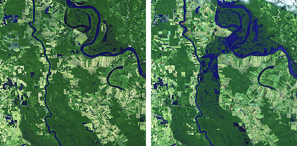
Landsat satellite images of the impact of the releasing of water from the Morganza spillway in Louisiana. Left, image capture from April of this year. Right, image capture as of May 18lth of this year. Courtesy of Ronald Beck, The Earth Resources Observation and Science Center.