
This time series is made from a combination of observations from the Special Sensor Microwave/Imagers (SSM/Is) flown on a series of Defense Meteorological Satellite Program missions and the Advanced Microwave Scanning Radiometer for EOS (AMSR-E), a Japanese-built sensor that flies on NASA’s Aqua satellite. These sensors measure microwave energy radiated from the Earth’s surface (sea ice and open water emit microwaves differently). Scientists use the observations to map sea ice concentrations.
Satnews Daily
May 26th, 2009
Here's Looking @ Earth: The Icy Underbelly
Unlike the Arctic — an ocean basin surrounded by land, where sea ice extends all the way to the pole — the Antarctic is a large continent surrounded by ocean. Because of this geography, the Antarctic’s sea ice extent is larger than the Arctic’s in winter, but smaller in the summer. Total Antarctic sea ice peaks in September (the end of Southern Hemisphere winter) and retreats to a minimum in February.
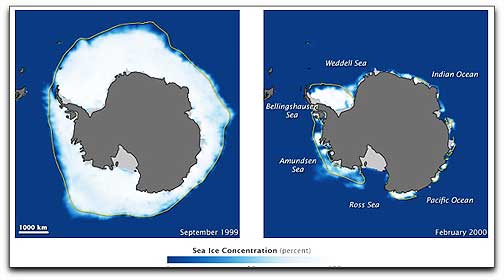 These image pairs show Antarctic sea ice during the September maximum (left) and the following February minimum (right) for a time series beginning in September 1999 and ending in February 2009. Land is dark gray, and ice shelves — thick slabs of ice grounded along the coast — are light gray. The yellow outline shows the median sea ice extent in September and February from 1979 (when routine satellite observations began) to 2000. Extent is the total area in which ice concentration is at least 15 percent. The median is the middle value. Half of the extents over the time period were larger than the line, and half were smaller. Since the start of the satellite record, total Antarctic sea ice has increased by about 1 percent per decade. Whether the small overall increase in sea ice extent is a sign of meaningful change in the Antarctic is uncertain because ice extents vary considerably from year to year and from sector to sector. Considered individually, only the Ross Sea sector had a significant positive trend, while sea ice extent has actually decreased in the Bellingshausen and Amundsen Seas.
This time series is made from a combination of observations from the Special Sensor Microwave/Imagers (SSM/Is) flown on a series of Defense Meteorological Satellite Program missions and the Advanced Microwave Scanning Radiometer for EOS (AMSR-E), a Japanese-built sensor that flies on NASA’s Aqua satellite. These sensors measure microwave energy radiated from the Earth’s surface (sea ice and open water emit microwaves differently). Scientists use the observations to map sea ice concentrations.
This time series is made from a combination of observations from the Special Sensor Microwave/Imagers (SSM/Is) flown on a series of Defense Meteorological Satellite Program missions and the Advanced Microwave Scanning Radiometer for EOS (AMSR-E), a Japanese-built sensor that flies on NASA’s Aqua satellite. These sensors measure microwave energy radiated from the Earth’s surface (sea ice and open water emit microwaves differently). Scientists use the observations to map sea ice concentrations.