

[SatNews] CompassData, a worldwide provider of geospatial data and services, has noted with great interest that the FAA has granted five regulatory exemptions for unmanned aircraft system (UAS) commercial operations.
Under Section 333 of the 2012 FAA Modernization and Reform Act (FMRA), the exemptions have been granted to four companies representing several industries that promise to benefit from UAS technology.
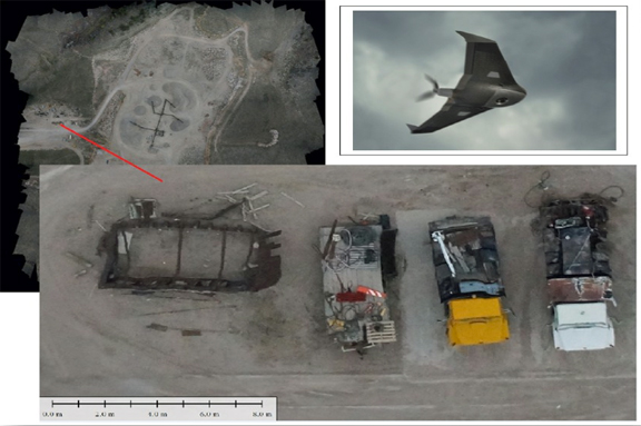
This specific image has an approximate pixel size of 2.5 cm, allowing details of the machinery to be seen, identification of tree and bush species, wetlands delineation, and easy mapping of the extents of the pit. The UX5 camera has a large imaging sensor that captures very sharp, color rich images, even in dark or cloudy conditions. The 16.1 MP camera and its custom optics give the UX5 the ability to capture data down to 2.4cm (0.94 in) resolution.
Trimble Navigation Limited, which manufactures the UX5 drone that CompassData owns and uses under current regulations for aerial surveys, is one of the commercial entities that could benefit from this exemption. The exemption should help to expedite the certificate of authorization (COA) application process by allowing for pre-approval of unmanned aircraft systems such as the UX5.
“The process of acquiring a certificate of authorization from the FAA, which is required to fly legally within U.S. airspace, can be cumbersome and time consuming. This exemption should help companies that use the Trimble UX5, like CompassData, accelerate this process and allow us to get into the field in a timely manner. This will benefit our customers,” said Jeff Southard, Senior Project Manager at CompassData. CompassData stresses that the Trimble exemption does not declare that future UX5 commercial operations are exempt from the COA process, but that the process may be accelerated as a result of the FAA exemption of the Trimble UX5.
CompassData announced the purchase of their first unmanned aircraft system (UAS), the Trimble UX5, in early 2014. They are one of just a handful of U.S. based companies with UX5 experience. The UX5 was selected because of CompassData’s and affiliated Trimble distributor CompassTools’ long history and also because it has received excellent reviews. The UX5, which comes with a custom camera system, was engineered specifically for mapping and surveying professionals who require highly accurate deliverables. In addition, it has a robust airframe and is easy to operate.
CompassData now has three Trimble certified remote pilots, with many hours of flight experience, prepared to conduct flight operations for custom aerial imagery collection projects. The “sky’s the limit” with potential applications: utility mapping, oil and gas fields, crop analysis, terrain modeling, volume calculations, mine mapping, tree height calculations, disaster relief, wildfire monitoring, livestock management, wildlife management and ranch mapping to mention a few.
For additional information, please visit the CompassData infosite at http://compassdatainc.com/
Trimble's UX5 infopage is located at http://www.trimble.com/agriculture/ux5