
 [SatNews] The Japan Aerospace Exploration Agency (JAXA) had been trying to communicate with the Advanced Land Observing Satellite DAICHI (ALOS) for about three weeks after the satellite developed a power generation anomaly.
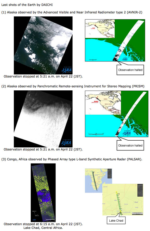
JAXA has decided to complete the satellite's operations by sending a halt command at 10:50 a.m. on May 12th (Japan Standard Time) as it was impossible to recover communication with the satellite. DAICHI, launched on January 24, 2006, (JST), had been operated for over five years, which was its target life and well beyond its design life of three years, and it achieved many fruitful results related to earth observations. JAXA continues to investigate the causes of the power generation anomaly based on the data we have acquired from the satellite, and will report the result to the Space Activities Commission of the Ministry of Education, Culture, Sports, Science and Technology, Japan. DAICHI's achievements included...
- Shot 6.5 million scenes of images by observing all over the Earth for five years
- Contributed to emergency observations of disaster-stricken areas
- Provided information both in Japan and overseas by observing about 100 large-scale disaster-stricken areas per year in accordance with requests. (Received a letter of appreciation from China after the great Sichuan earthquake)
- In addition to the filming at the time of an emergency, the DAICHI also contributed to compiling hazard maps and monitoring active volcanoes Took 400 scenes at the time of the Great East Japan
- Earthquake to contribute to information provision to 10 prefectural and municipal governments and organizations as well as to the central government's information gathering activities
- Thanks to DAICHI's active contribution to overseas rescue operations at the time of major disasters, JAXA was able to receive about 5,000 scenes of images from overseas at the time of the Great East Japan Earthquake through the International Charter Space and Major Disasters and the Sentinel Asia.
- Data utilization for mapping and updating topographic maps of 1/25,000 by the Geospatial Information Authority of Japan, as well as for mapping in African countries
- Contributing to the field of the Earth's environment including monitoring deforestation in Brazil, and cooperation with the World Bank (to monitor the impact of climate change)