

[SatNews] Marking a first in space, Sentinel-1A and Alphasat have linked up by laser stretching almost 36,000km across space to deliver images of Earth just moments after they were captured by the satellites.
This important step demonstrates the potential of Europe’s new space data highway to relay large volumes of data very quickly so that information from Earth-observing missions can be even more readily available. Having timely access to imagery from the Sentinel-1 mission, for example, is essential for numerous applications such as maritime safety and helping to respond to natural disasters. Orbiting from pole to pole about 700 km up, Sentinel-1A transmits data to Earth routinely, but only when it passes over its ground stations in Europe. However, geostationary satellites, hovering 36 000 km above Earth, have their ground stations in permanent view so they can stream data to Earth all the time. This takes a great deal of coordination between the different teams working intensively. Later on, in routine operations, this will be fully automated.
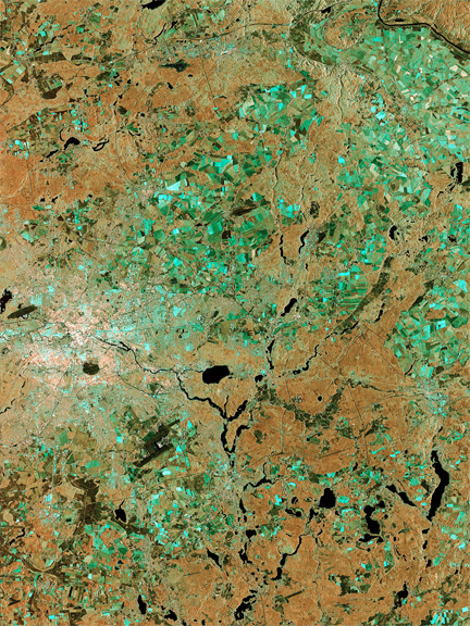
This image of Berlin, Germany, captured by Sentinel-1A is one of the first images delivered via the precursor European Data Relay System (EDRS) carried on Alphasat, which is in geostationary orbit 36 000 km above Earth. The image is a result of the two satellites using their optical communications instruments to transfer data via laser for fast delivery.
Alphasat’s ‘technology demonstration payload’ shows how the EDRS space data highway will make large volumes of data from satellites in low orbit available almost instantly. Sentinel-1A transmits data to Earth routinely when passing over ground stations in Norway, Italy and Spain.
Complementing the Sentinel ground-station network, EDRS connects with the satellite and collects data via laser and then transmits the data in near-real time to the ground – essential for applications such as maritime safety and for helping respond to disasters such as floods.
The first EDRS element will be carried on the Eutelsat-9B satellite, which will be launched next year. In the meantime, Sentinel-1A will be able to connect through the laser communications terminal on Alphasat. Sentinel-2A, scheduled to be launched next spring, also carries the same optical communications payload.
Image courtesy of ESA.
Creating a link between the two kinds of satellites means that more information can be streamed to Earth, and almost continuously. Engineers have turned to laser to accomplish this. Funded by ESA and the DLR German Aerospace Center, Tesat has developed a laser communications terminal and downlink system that is carried on the geostationary Alphasat, Europe’s largest telecommunications satellite. This novel unit’s counterpart is flying on Sentinel-1A. Over the past few weeks the Sentinel-1A operations teams at ESA’s European Space Operations Centre, ESOC, in Darmstadt, Germany, and ESA’s Earth Observation Centre, ESRIN, in Frascati, Italy, and German Space Operations Center, GSOC, in Oberpfaffenhofen, Germany, have been working intensively to prepare for the first laser link tests.
The image on the right, showing Berlin in Germany, is one of the first images delivered using this state-of-the-art technology.
“Demonstrating laser data link-ups in space has involved excellent teamwork by many at ESA, Inmarsat, Tesat and DLR,” says ESA’s Head of Mission Operations, Paolo Ferri. “I am especially proud of the major contribution the operations teams at ESOC and ESRIN have provided to the success of this activity, which will significantly improve data availability from Earth observation missions and enhance benefits for all citizens in the future.”
Heads of various agencies gathered at ESOC to follow the operators as they linked the two satellites by laser. Radar data over Asia were acquired and downlink to Earth in near-real time.
Magali Vaissiere, ESA’s Director of Telecommunications and Integrated Applications, said, “Today, space systems have become part of the global Big Data challenge. “You can visualize the link of today as an optical fibre in the sky that can connect the Sentinels back home to Europe, from wherever they are on their orbit around Earth. The link is operated at 1.8Gbit/s, with a design that could scale up to 7.2Gbit/s in the future. Never has so much data traveled in space.”
Following processing by ESA’s Copernicus Ground Segment, images will be online and available to the public through the Sentinel data infosite, which is located at https://sentinel.esa.int/web/sentinel/home.