
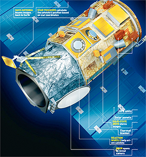
Artistic rendition and onboard instrument locations of the GeoEye-1 satellite
...Government of India for stereo imagery from the GeoEye-1 satellite to support development of India’s freight railway corridor. Stereo imagery provides three-dimensional viewing and feature recognition for a number of engineering applications, including three-dimensional feature extraction.
RITES, a Government of India Enterprise, made the six-figure purchase through the National Remote Sensing Centre (NRSC), GeoEye’s Master Reseller for India. They provide engineering, consulting and project management services to India’s transportation infrastructure sector. This new customer will receive GeoEye-1′s 50-centimetre stereo imagery products, reportedly the highest resolution satellite imagery that is commercially available worldwide. RITES will use this imagery for the planning, design and alignment of two high-speed transportation corridors within India. NRSC will oversee the delivery of the imagery to RITES and the Indian Railways Ministry.