

[SatNews] Skybox Imaging, acquired by Google in August of 2014, has teamed up with the search engine giant to provide nonprofit movers and shakers with vital, high quality satellite imagery that would otherwise come at a steep price tag.
Skybox co-founder & Developer Advocate for Google Earth Outreach, Julian Mann, announced the program on Skybox’s infosite on October 23:
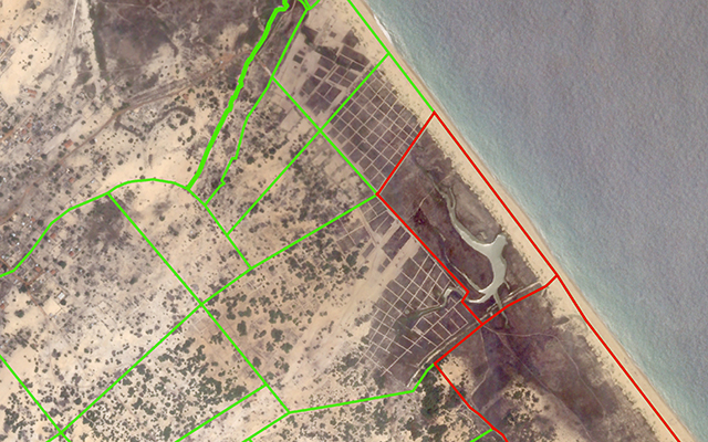
October 3, 2014 I Nagarkovil, Sri Lanka I SkySat-1
“When we started Skybox in 2009 we knew that we had a tremendous opportunity to leverage our imaging capability for positive change in the world. We would be capturing the world at high resolution and with unmatched frequency. As soon as SkySat-1 was in orbit we began monitoring sites critical to our understanding of global climate change, such as the Helheim Glacier in Greenland.
"We also partnered with organizations like the Harvard Humanitarian Initiative’s Signal Program who use our imagery to help develop tools for Internally Displaced Persons camp management in Africa and the Middle East.
"I’ve always been impressed by how access to global satellite imagery through Google Earth and Maps has changed the way people see their world—from the cities they live in to faraway places. In my new role on theGoogle Earth Outreach team, I have been astounded by the way these tools have changed how our partners do their work and tell their amazing stories. I have also learned that one of the most frequent questions is 'Can you get us newer images of this place?'
"And I’m excited to say that now the answer is 'YES, we can get new satellite imagery for you!' Today (October 23), at our annual Geo for Good User Summit, we announced the Skybox for Good program, under which we will contribute fresh satellite imagery to projects that save lives, protect the environment, promote education, and positively impact humanity. We’ve captured some images of Nagarkovil village in Northern Sri Lanka. HALO Trustpreviously cleared landmines in this area and used updated imagery to help verify that people are returning, having built 84 houses and cultivating over 40 hectares of agricultural land.
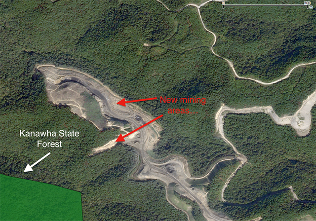
October 2, 2014 I KD-2 Mine, West Virginia I SkySat-2
"In this beta phase of the program, we will select a small group of organizations and acquire the imagery they need to accelerate their work. The images collected for these partners are being made available publicly, under a Creative Commons By Attribution license (CC BY 4.0), for everyone to see and use. We’ve already started collecting a few images, which you can see on this map. Check out the images in West Virginia, where SkyTruthand Appalachian Voices are monitoring and measuring the rapid expansion of mountaintop-removal (MTR) mining which is devastating forests and communities across Appalachia, visible in the image below, right next to the popular hiking trails of Kanawha State Forest.
"Google Earth Outreach gives nonprofits and public benefit organizations the knowledge and resources they need to visualize their cause and tell their story. In the future, we hope to expand the program to allow many more non-profit organizations and public interest groups to benefit from the use of Skybox data.
"As part of Google, we are inspired by the opportunity to up our game and make a difference at a much larger scale.”
For more information, please visit the Skybox Imaging infosite.
For further updates as the program is expanded, follow @earthoutreach on Twitter.