
Airbus Defence and Space has released a new version of The OneAtlas Platform, the company's collaborative environment to easily access premium imagery, perform large-scale image processing, extract industry-specific insights and benefit from Airbus assets for solution development.
The OneAtlas Platform provides access to data within the Living Library as well as value-added layers, Basemap and WorldDEM. The Living Library contains multi-resolution and premium optical satellite data, updated on a daily basis and immediately available via streaming, download and API. Basemap is a curated global imagery layer, updated annually and created from 1.5 and 0.5 meter resolution imagery. WorldDEM dataset, for 3D analytics and rendering, is available in streaming format.
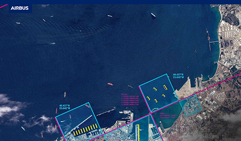
The OneAtlas Platform also combines premium imagery and industry-leading expertise to deliver Thematic Services. There are new change detection capabilities that allow for monitoring and analysis using machine learning to automatically detect and identify infrastructure changes. Ocean Finder, for maritime-focused applications, allows users to directly order satellite-based maritime detection and identification reports. Additional Thematic Services include those to help serve environmental needs: Starling, that supports companies monitor their forest impact with unprecedented accuracy and Verde, a new API service that delivers detailed crop analytics with easy-to-use vegetation maps.
OneAtlas is available now at oneatlas.airbus.com and will be soon accessible by mobile app — a free, 30 day trial of OneAtlas is available. Learn more about OneAtlas in the company's webinar on March 7. Sign up here.
Executive Comment
Francois Lombard, Head of the Intelligence Business at Airbus Defence and Space, said the OneAtlas Platform is the cornerstone of disseminating the company's imagery and services and provides immediate access to data and analytics and gets it into the hands of many more users and partners to create new business opportunities. The OneAtlas Platform is a cutting-edge tool for the geospatial community.