
[SatNews] Scene Sharp(tm) USA will introduce Version 2.0 of its Fuze Go™ universal image fusion technology April 14-17, 2014, at the GEOINT 13* Symposium in Tampa, Florida.
Scene Sharp will be hosted in Global Marketing Insights booth #2091, where it will demonstrate the new Fuze Go MS Sharp and Fuze Go SAR Sharp image fusion processing tools. A division of PraEis Ltd., Scene Sharp USA will also introduce Kevin Marasch as its new Client Distribution Manager for the Fuze Go product line. PraEis Ltd. is a geospatially focused technology transfer organization with offices in Ohio and New Hampshire USA.
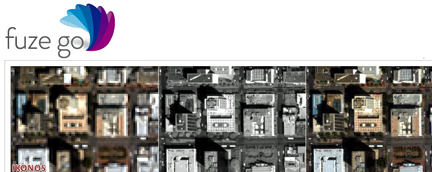
“Fuze Go is a fully automated technology that enables users to quickly and easily fuse data sets to add color to non-colorized satellite and aerial imagery with just a few mouse clicks,” said Scene Sharp CEO Ian Lucas. “By colorizing image data, GIS users can visualize and extract richer information content from remotely sensed data to make better informed decisions.”
In one simple step, the Fuze Go MS Sharp software fuses high-resolution panchromatic image data with lower-resolution multispectral data to generate a high-resolution color image. The full information content of the multispectral bands is retained in the fused image. More importantly, Fuze Go MS Sharp is the only fusion software capable of simultaneously merging up to 30 bands of multispectral data with a panchromatic image. “Fuze Go MS Sharp runs at least five times faster and yields more consistent results than pan-sharpening applications that can only process four bands of data,” said Lucas. “As is true with the entire line of existing and planned Fuze Go products from Scene Sharp, no expertise in GIS or image processing is needed to use Fuze Go MS Sharp.”
As a universal image fusion tool, Fuze Go MS Sharp can handle data formats from any commercial image processing and enterprise GIS software packages. In cooperation with Exelis Inc., Scene Sharp created a Fuze Go MS Sharp plugin for the popular Exelis ENVI® 5.0 and 5.1 image processing package. “The plugin enables ENVI users to access the Fuze Go MS Sharp tool either within the ENVI workflow or outside of it so that fusion can be performed as a stand-alone application, freeing up the ENVI software license for other image processing activities,” said Lucas. “We are developing similar plugin capabilities for other major GIS and image processing packages.”
Fuze Go SAR Sharp was designed by Scene Sharp for more effective exploitation of data captured by satellite-based synthetic aperture radar (SAR) sensors. Fuze Go SAR Sharp fuses gray-scale radar data with optical multispectral bands to colorize the SAR data set. This image fusion presents the unique SAR data, which is captured through darkness and clouds, in a color context that greatly enhances the user’s ability to interpret the radar data and extract actionable intelligence from it. Fuze Go MS Sharp and SAR Sharp are available for purchase for an annual license fee. Batch processing versions of the software packages are also offered to perform automatic fusion of multiple optical or SAR scenes.
To learn more about the Fuze Go products, please visit http://www.fuzego.com/ to try the software.