
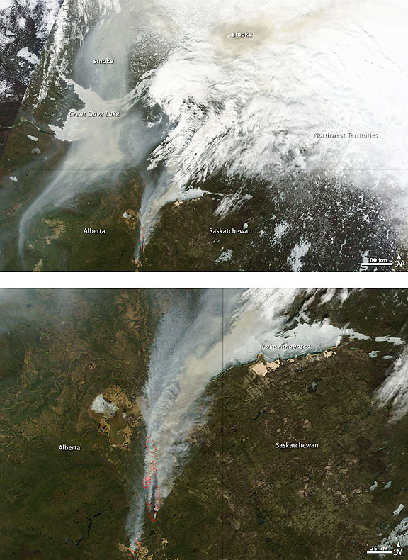
At 10:00 a.m., the Alberta government reported 116 fires burning in the province, 34 of which were out of control. The following day, the total number of fires had dropped to 100, and the number of uncontrolled fires had dropped to 22, but four new fires had started to burn out of control. The Moderate Resolution Imaging Spectroradiometer (MODIS) on NASA’s Terra satellite took this image at 12:35 p.m. local time on May 16. Similar images of central Canada are available twice daily.
NASA images courtesy the MODIS Rapid Response Team at NASA GSFC. Caption by Holli Riebeek and Michon Scott.
The top view shows a wide area to illustrate how far the smoke traveled. The lower image provides a closer view of a massive fire burning south of Lake Athabasca. Fire detections are outlined in red. Strong winds fanned the fires on May 15 and 16, pulling thick plumes of smoke north. The fires forced some energy and transportation companies to suspend operations, reported CBC News. Multiple petroleum companies suspended drilling in the region and moved their employees to safety. A pipeline closure and halted railway service hampered oil transport. Meanwhile, fires near Lesser Slave Lake destroyed 40 percent of the town of Slave Lake on May 15, including hundreds of homes and businesses, and the town hall. On May 17, CBC News reported that British Columbia was sending 200 more firefighters, in addition to the 130 firefighters already deployed to Alberta the previous day. Fire danger remained extreme throughout much of northern Alberta on May 17, the government reported.