
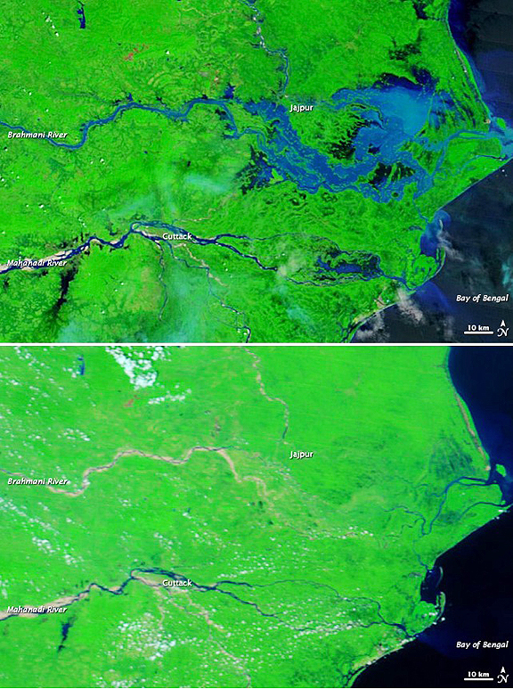
On September 27, 2011, the 4 reported that the second period of heavy rainfall had claimed 27 lives. The Moderate Resolution Imaging Spectroradiometer (MODIS) on NASA’s Terra satellite captured the top image on September 27, 2011. For comparison, the bottom image shows the same area a year earlier, on September 28, 2010. These images show parts of the Brahmani and Mahanadi Rivers near the Bay of Bengal. Both images use a combination of infrared and visible light to increase contrast between water and land. Water varies in color from electric blue to navy. Vegetation is bright green. Bare ground is earth toned. Clouds range in color from off-white to pale blue-green.
NASA images courtesy the MODIS Rapid Response Team at NASA GSFC.
Caption by Michon Scott.
The most striking difference between these images is the large expanse of flood water around the city of Jajpur. Jajpur District was hardest hit by the second round of flooding in September 2011, cut off from the outside world, according to The Hindu. In the image from September 2011, the city of Jajpur is largely surrounded by flood water. A significant area of flood water also occurs along the Mahanadi River east of Cuttack. At the mouth of the Brahmani River, water in the Bay of Bengal is much lighter in color in 2011 than in 2010. This may result from increased sediment carried by the flooded river. ABC News Australia linked the floods to unusually heavy rains occurring late in the monsoon season. By September 27, the Hindustan Times reported, flooding had eased somewhat in parts of Orissa, but many villages remained marooned, and the government planned to continue air drops of food and supplies to isolated areas.