
“NOAA’s data opens up the fascinating world underneath the planet’s largest fresh water system,” said Richard W. Spinrad, NOAA assistant administrator for oceanic and atmospheric research and a Google advisory board member. “As an oceanographer, I find this an exciting use of scientific data to serve society.” Visitors to the new Great Lakes feature can explore the canyons and sandbars in eastern Lake Superior, the Lake Michigan mid-lake reef complex, and the old river channel — now underwater — that once connected Lakes Michigan and Huron at the Straits of Mackinac.
Satnews Daily
April 23rd, 2009
Here's Looking @ Earth... Great Views Of The Great Lakes
NOAA is helping Americans peer beneath the surfaces of the five Great Lakes by providing Google Earth with data that now includes detailed three-dimensional mapping of Lakes Huron, Ontario, Erie, Superior, and Michigan.
“NOAA’s data opens up the fascinating world underneath the planet’s largest fresh water system,” said Richard W. Spinrad, NOAA assistant administrator for oceanic and atmospheric research and a Google advisory board member. “As an oceanographer, I find this an exciting use of scientific data to serve society.” Visitors to the new Great Lakes feature can explore the canyons and sandbars in eastern Lake Superior, the Lake Michigan mid-lake reef complex, and the old river channel — now underwater — that once connected Lakes Michigan and Huron at the Straits of Mackinac.
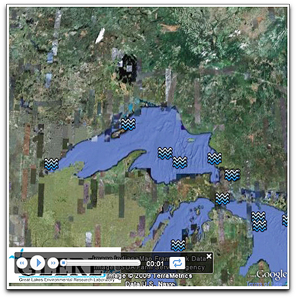 NOAA’s Great Lakes Environmental Research Laboratory (GLERL) in Ann Arbor, Michigan, teamed up with the National Geophysical Data Center (NGDC) in Boulder, Colorado, to produce the Google Earth tour to highlight some of the interesting coastal and subsurface features. The original Great Lakes bathymetric data were compiled by a NOAA NGDC-GLERL and Canadian Hydrographic Service team from archival U.S. and Canadian soundings spanning more than 75 years. David Schwab, a physical oceanographer at GLERL, generated a map of lake depths from the joint project and provided it to Google to form the basis for the Great Lakes topography. The Great Lakes are the largest system of fresh surface water on Earth, containing roughly 18 percent of the world supply. The lakes contain enough water to cover the entire surface of the continental United States to a depth of nine feet. The Great Lakes span more than 750 miles from west to east and their shoreline is equal to almost 44 percent of the circumference of the globe. Michigan's Great Lakes coastline alone is over 3,200 miles long, which is more coastline than any state but Alaska. To highlight some of the interesting coastal and subsurface features of the Great Lakes, the NOAA Great Lakes Environmental Research Laboratory has assembled a narrated Google Earth tour. NOAA understands and predicts changes in the Earth's environment, from the depths of the ocean to the surface of the sun, and conserves and manages our coastal and marine resources.
“NOAA’s data opens up the fascinating world underneath the planet’s largest fresh water system,” said Richard W. Spinrad, NOAA assistant administrator for oceanic and atmospheric research and a Google advisory board member. “As an oceanographer, I find this an exciting use of scientific data to serve society.” Visitors to the new Great Lakes feature can explore the canyons and sandbars in eastern Lake Superior, the Lake Michigan mid-lake reef complex, and the old river channel — now underwater — that once connected Lakes Michigan and Huron at the Straits of Mackinac.