
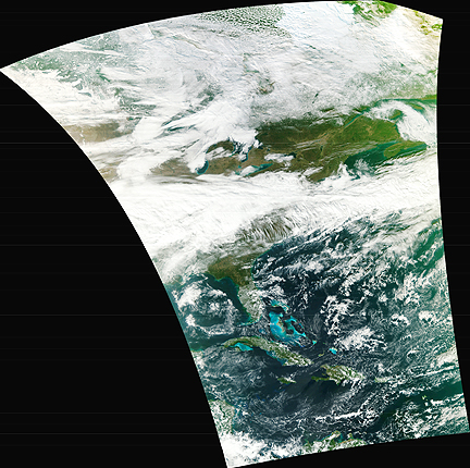
The NPP Satellite's first VIIRS image acquisition, courtesy of Ball Aerospace
The Visible Infrared Imager Radiometer Suite (VIIRS) onboard NASA's newest Earth-observing satellite, NPP, acquired its first measurements on Nov. 21, 2011. This high-resolution image is of a broad swath of Eastern North America from Canada’s Hudson Bay past Florida to the northern coast of Venezuela. The VIIRS data were processed at the NOAA Satellite Operations Facility (NSOF) in Suitland, Maryland.
VIIRS is one of five instruments onboard the National Polar-orbiting Operational Environmental Satellite System Preparatory Project (NPP) satellite that launched from Vandenberg Air Force Base, California, on October 28th. Since then, NPP reached its final orbit at an altitude of 512 miles (824 kilometers), powered on all instruments and is traveling around the Earth at 16,640 miles an hour (eight kilometers per second).
VIIRS will collect radiometric imagery in visible and infrared wavelengths of the Earth's land, atmosphere, and oceans. By far the largest instrument onboard NPP, VIIRS weighs about 556 pounds (252 kilograms). Its data, collected from 22 channels across the electromagnetic spectrum, will be used to observe the Earth's surface including fires, ice, ocean color, vegetation, clouds, and land and sea surface temperatures. NPP serves as a bridge mission from NASA's Earth Observing System (EOS) of satellites to the next-generation Joint Polar Satellite System (JPSS), a National Oceanic and Atmospheric Administration (NOAA) program that will also collect weather and climate data.
Then, the Advanced Technology Microwave Sounder (ATMS) on board NASA's newest Earth-observing satellite, NPP, acquired its first measurements on November 8, 2011. The image below shows the ATMS channel 18 data, which measures water vapor in the lower atmosphere. Tropical Storm Sean is visible in the data, as the patch of blue, in the Atlantic off the coast of the Southeastern United States. The data were processed at the NOAA Satellite Operations Facility (NSOF) in Suitland, Maryland. The ATMS is one of five instruments on board the National Polar-orbiting Operational Environmental Satellite System Preparatory Project, or NPP, that launched from Vandenberg Air Force Base, California, on October 28th.
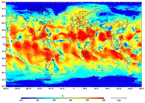
The first ATMS data capture for NPP
A passive microwave radiometer, the ATMS instrument can collect data even when it is cloudy. Paired with the Cross-track Infrared Sounder (CrIS), also aboard NPP, they will produce global sets of high-resolution temperature and moisture profiles that are used for forecasting and studying weather. In addition to the ATMS and the CrIS instruments, NPP carries three more state-of-the-art sensors that will provide critical information concerning long-term climate patterns and will help meteorologists improve short-term weather forecasts. During the satellite's five-year life, the mission will extend more than 30 key long-term datasets NASA has been tracking, including measurements of the ozone layer, and land and ice cover.
NPP serves as a bridge mission between NASA's Earth Observing System (EOS) of satellites and the next-generation Joint Polar Satellite System, a National Oceanic and Atmospheric Administration (NOAA) program that will also collect weather and climate data.
The NPP mission is managed by NASA's Goddard Space Flight Center in Greenbelt, Md., for the Earth Science Division of the Science Mission Directorate at NASA Headquarters in Washington. The Joint Polar Satellite System program provides the NPP ground system. NOAA will provide operational support for the mission. NASA Goddard manages the NPP mission for the Earth Science Division of the Science Mission Directorate at NASA Headquarters in Washington. The JPSS program provides the NPP ground system and NOAA provides operational support.
During NPP's five-year life, the mission will extend more than 30 key long-term datasets that include measurements of the atmosphere, land and oceans. NASA has been tracking many of these properties for decades. NPP will continue measurements of land surface vegetation, sea surface temperature, and atmospheric ozone that began more than 25 years ago.