
...over the last 15 years. A change in wind direction could cause the water to spill into the north Atlantic, cooling Europe. The results are remarkable: since 2002, the sea surface in the studied area has risen by about 15cm, and the volume of fresh water has increased by some 8000 cubic km – around 10 percent of all the fresh water in the Arctic Ocean. Researchers from the Centre for Polar Observation and Modelling (CPOM) at University College London and the U.K.’s National Oceanography Centre used data from ESA’s ERS-2 and Envisat satellites to measure sea-surface height over the western Arctic from 1995 to 2010. The results were recently published in the online version of the scientific journal, Nature Geoscience.
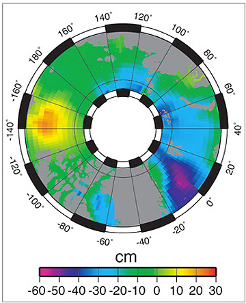
Arctic Ocean mean sea-surface with respect to the geoid for the past 15 years of satellite radar altimetry data. The Beaufort Gyre is the yellow/orange dome in the Western Arctic. Credits: CPOM/UCL/ESA/Planetary Visions
“When we looked at our data on a year-to-year basis, we noticed that the changes in the sea surface height did not always follow what the wind was doing, so we thought about reasons why this might happen,” said Katharine Giles, CPOM research fellow and lead author of the study. “One idea is that sea ice forms a barrier between the atmosphere and the ocean. So as the sea ice cover changes, the effect of the wind on the ocean might also change. Our next step is to look into how changes in the sea ice cover might affect the coupling between the atmosphere and the ocean in more detail to see if we can confirm this idea.”
Sea ice can be measured by different types of satellite data. Radar altimeters on satellites such as the two used in the study, Envisat and ERS-2, can be particularly useful when observing inaccessible areas like the Arctic.
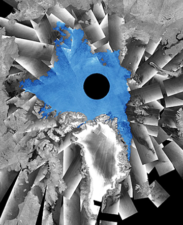
This is a mosaic of Envisat radar images acquired between 9 and 11 September 2011 over the Arctic Ocean. The sea ice extent highlighted in blue corresponds to the areas where more than 80% of the sea surface is covered by ice (from an analysis performed by the US National Ice Center). The Arctic is one of the most inaccessible regions on Earth, so obtaining measurements of sea ice was difficult before the advent of satellites. Credits: ESA/DMI/NIC
ESA will continue to monitor the Arctic with the upcoming Sentinel series of Earth-observing satellites for Europe’s Global Monitoring for Environment and Security (GMES) program. Later this year, the first results of seasonal changes in sea-ice thickness from data acquired by ESA’s CryoSat-2 satellite will be presented.