Satnews Daily
April 29th, 2013
SSTL... Ocean Activity Scrutinized By SAR (Imagery)
[SatNews] Surrey Satellite Technology Ltd. (SSTL) publishes a Space Blog at their website that is...
...replete with information regarding their spatial developments. An example of their offerings is their latest article entitled "Space Radar Exposes Ocean Activity."
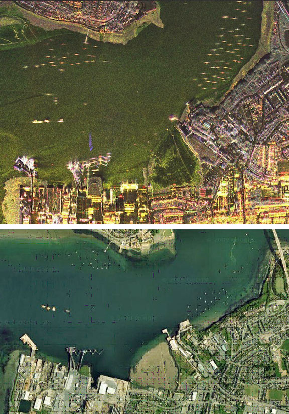
Shipping in Pembroke Dock. S-band SAR image (top)is courtesy of Astrium UK, the optical image (bottom) is courtesy of Google Earth. Individual ships are more easily discernible in the S-band SAR image than in the optical image.
"The ocean covers 71 percent of the Earth’s surface and moves 90 percent of its commerce, yet our ability to monitor activity on the ocean is far less developed than on land.
Over the last three decades, optical satellites have become a necessity when it comes to monitoring areas that are hard to reach on foot, such as large forests or arctic regions, however, the ocean’s high level of cloud cover and vastness has limited the effectiveness of optical satellites for monitoring maritime activity. Increasingly,
Synthetic Aperture Radar (SAR) technology is being used from space, imaging through cloud and in darkness by detecting surface textures instead of reflected light.
Previously, SAR payloads were too big and used too much power to be carried by anything other than very large satellite platforms, making space SAR services extremely costly. However, small satellites have become increasingly capable and SSTL has developed a new low-cost space radar system called NovaSAR, which will make this technology more accessible. NovaSAR was made possible with a new small satellite SAR payload, developed by Astrium, and building on SSTL’s flight-proven 300kg platform to increase power capabilities."
SSTL has long promoted the virtue of constellations of small satellites to increase the volume of data that can be acquired and improve revisit times, for a cost comparable to larger single missions. NovaSAR satellites will offer high data throughput of at least one million sq. km per day, and a constellation of three satellites could image any point on the globe every day, regardless of local time or weather."
 NovaSAR-S spacecraft with payload antenna (left), component accommodation (center), and solar panel (right, image courtesy of SSTL, Astrium.
NovaSAR’s technology has been application–led and engineers have developed four imaging modes that will serve specific applications. One of these is a dedicated maritime mode that will provide a very wide swath area of 750km allowing NovaSAR to image large areas across the world’s ocean in medium resolution. This will make NovaSAR satellites ideal for monitoring large-scale environmental disasters such as the oil spill disaster at the Deep Water Horizon platform in 2010, as well as monitoring Arctic ice in shipping channels, tracking vessels over large areas and monitoring shipping routes in areas of the world that at times are in almost constant darkness, like Scandinavia."
NovaSAR can also assist offshore policing by monitoring illegal activity such as piracy, smuggling and illegal fishing which often occur at night. Current maritime tracking systems such as AIS (Automatic Identification System) are ‘opt in’, however very often the vessels which the authorities most want to track are those which have not ‘opted in’ to AIS, and locating these at night can be a hit-and-miss endeavour. NovaSAR can fly both AIS and SAR payloads together to provide an accurate picture of what is happening at a given time, combining the data to flag up unexpected maritime activity. Correlating AIS data with the SAR imagery means that authorities don’t have to stop and check each vessel, only those flagged as anomolies, thus targeting maritime policing more effectively. This is a system that is currently being trialled in Canada, with good early results."
Space radar applications was the topic on the agenda at the second day of the 2013 DMC Conference recently held in London and a presentation on NovaSAR's maritime applications can be viewed on the website."
Topical Tags :
Regional Tags :
