
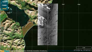
Position of EROS B 7x14 km scene. Acquired on December 25, 2011 (ImageSat, ScanEx RDC, 2011)
[SatNews] Satellite images reveal a ship trapped in ice that, until now, would have been impossible to view...
Possibility to carry out space imagery of the Extreme North areas in the conditions of insufficient illumination has been confirmed. In late December 2011 ScanEx Research & Development Center conducted satellite imagery of the Oriental Angel injured ship, thrown onto the coast of the Chukot Peninsula (62.5 degrees of north latitude).
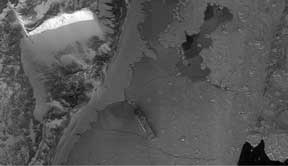
Oriental Angel ship in the state of emergency near Cape of Military Topographers on December 25, 2011. Elevation – minus 0.4 degrees . Ship has almost no shadow in twilight. EROS B image, spatial resolution - 0.7 m. Image processed using ScanEx Image Processor software application (ImageSat, ScanEx RDC, 2011)
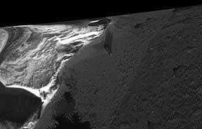
Oriental Angel ship in the state of emergency in fast ice near Cape of Military Topographers (Chukchi Autonomous Area) on December 26, 2011. Elevation - 0,6 degrees. Heavy fog. EROS B image, spatial resolution – 0.7 (ImageSat, ScanEx RDC, 2011)
Elevation indicating level of illumination constituted from 0 to 1-2 degrees. Received images allowed assessing the condition and location of the injured vessel frozen into the fast ice at the Cape of Military Topographers. For the unique series of the Chukotka area images EROS A and EROS B satellites were used. These satellites ensured creation of images in asynchronous mode with accumulation of signals by slowing down the scanning.
ScanEx RDC offers services on operational detailed imaging of sites in northern regions under conditions of insufficient illumination in winter periods. Areas of emergency situations, industrial facilities and sites being constructed or residential areas can be the objects of imaging. Space imaging is an effective tool to assess damage caused by emergencies, to control industrial activities and current situation.
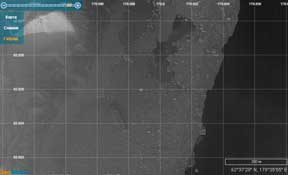
For precision pointing of the optical EROS B camera radar images from RADARSAT-2 were used (UltraFine mode), spatial resolution – 3 m. Acquisition date: December 20, 2011. Due to heavy offshore north-western wind water openings and ice clearings formed in the ice around the ship. (MDA, ScanEx RDC, 2011)
Imaging of sites can be carried out with a specified interval or according to terms of “tangible” stages and results of construction or industrial activities, marked out in the calendar plan. Different combinations of using the archived and new tasking data are possible.
Proprietary ground receiving complexes of ScanEx RDC will allow high operability of imaging in Russia. They are equipped with universal small-size UniScan stations and software tools for data processing, archiving and transmission of end products. This technology enables to quickly monitor a large number of geographically scattered sites.
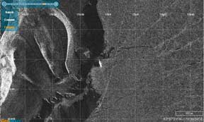
Oriental Angel ship in the state of emergency in fast ice near Cape of Military Topographers (Chukchi Autonomous Area). Acquisition date: December 23, 2011. Elevation – 3.7 degrees. EROS А image, spatial resolution – 2.5 m (ImageSat, ScanEx RDC, 2011)