
Google said in a blog post that it had worked with satellite company GeoEye to obtain the high resolution post-earthquake pictures.
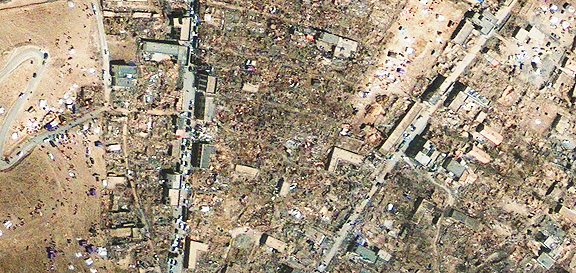
GeoEye released the half-meter resolution satellite image of Yushu, a city in northwest China (above), captured one day after a 7.1-magnitude earthquake struck the area on April 14,2010. Although high-rise buildings appear to be standing, likely due to modern construction standards, there is extensive destruction to smaller structures in the lower left quadrant of the image. These smaller dwellings have been largely reduced to rubble. Vehicles crowd the main street near the town square along the river where people have gathered and temporary structures have been erected. Bridges appear to be intact but could be damaged. The image was taken by the GeoEye-1 satellite from 423 miles in space on April 15, 2010 as it moved from north to south over China at a speed of four miles per second.