
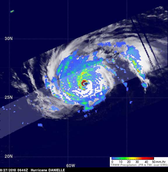
This TRMM image of Hurricane Danielle's rainfall was captured on August 27 06:46 UTC (2:46 a.m. EDT) and showed that Danielle now has a well-formed eye surrounded by sharply curved rainbands--all signs of mature storm with an intense circulation. There are very powerful thunderstorms in Danielle's eye wall dropping extreme amounts of rain, especially in the northwest quadrant (dark red areas). Credit: NASA/SSAI, Hal Pierce
Danielle, which had been a Category 2 storm the day before with sustained winds estimated at around 95 knots (~110 mph) by the National Hurricane Center, quickly intensified overnight and by morning was a power Category 4 hurricane on the Saffir-Simpson scale with sustained winds of 115 knots (132 mph). Two images were taken from TRMM at 06:46 UTC (2:46 a.m. EDT) on August 27. The first image showed a top-down view of the horizontal pattern of rain intensity within the storm. Rain rates in the center of the swath are from the TRMM Precipitation Radar (PR), and those in the outer swath are from the TRMM Microwave Imager (TMI).The rain rates are overlaid on infrared (IR) data from the TRMM Visible Infrared Scanner (VIRS), and are created at NASA Goddard. TRMM is managed by NASA and the Japanese Space Agency, JAXA.
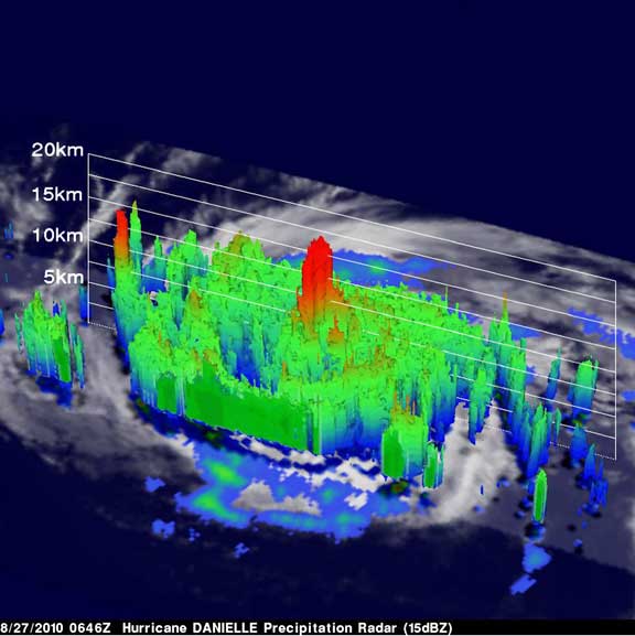
A 3D view of Danielle shows an area of deep convective towers (red) are prominently visible in the center of the storm. These tall towers are the key to Danielle's intensification. They are associated with the strong thunderstorms responsible for the areas of intense rain. Credit: NASA/SSAI, Hal Pierce
Danielle was still a powerful Category 4 hurricane on the Saffir-Simpson scale on Friday, August 27, at 11 a.m., EDT. She had maximum sustained winds near 135 mph, and was moving northwest near 12 mph. Danielle's center was about 480 miles southeast of Bermuda near 26.9 North and 59.8 West. Her minimum central pressure is 946 millibars. Although Danielle is not expected to be directly affected by the hurricane, Danielle will create large and dangerous surf conditions in Bermuda over the weekend. Those large ocean swells will also begin affecting the U.S. east coast beginning this weekend into next week. Beachgoers along the U.S. eastern seaboard should be aware of dangerous rip currents as a result of Danielle's passage. Danielle is expected to remain a major hurricane until it recurves east of Bermuda and then weaken as it moves northeastward over cooler waters in the central Atlantic. (Text credit: Steve Lang/NASA SSAI and Rob Gutro/NASA's Goddard Space Flight Center, Greenbelt, Md.)