

A NOAA geostationary satellite played a pivotal role in the July 23rd rescue of a group of student hikers from a vicious grizzly bear attack in Alaska, helping direct first responders to the scene. The teenagers were hiking through the Alaska wilderness and crossing a creek about 93 miles north of Anchorage when the bear attacked. Of the four teens injured by the attack, two required hospitalization. Other members of the hiking troop activated an emergency personal locator beacon. NOAA’s GOES-11 spacecraft first picked up the beacon’s distress signal, and a European polar-orbiting satellite, flying closer to Earth, pinpointed the actual location of the hikers. The information was relayed to the Alaska Rescue Coordination Center, which alerted Alaska State Troopers and the Alaska Air National Guard who rescued the teens.
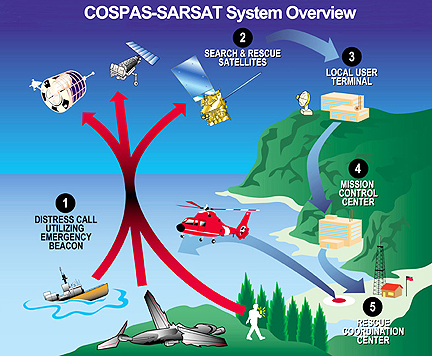
NOAA satellites are a part of an international satellite-aided search and rescue system known as SARSAT that helps first responders locate people in distress by detecting signals from hand-held personal locator beacons or from emergency beacons mounted onboard boats and aircraft.
Credit: NOAA SARSAT.
“A major tragedy was averted because COSPAS-SARSAT and the satellites and first responders that make the system work were in place,” said Chris O’Connors, program manager for NOAA SARSAT. When a NOAA satellite finds the location of a distress signal within the United States or its surrounding waters, it relays the information to the SARSAT Mission Control Center based at NOAA’s Satellite Operations Facility in Suitland, Md. From there, the information is quickly sent to a rescue coordination center operated by either the U.S. Air Force (for land rescues) or the U.S. Coast Guard (for water rescues).
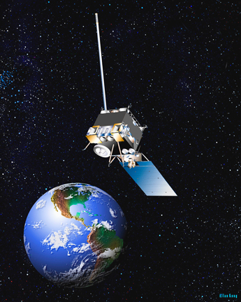
NOAA’s GOES 11 satellite helped pinpoint the location of a group of teen hikers in need of emergency medical attention after they were attacked by a bear in the Alaska wilderness. Credit: NOAA.