
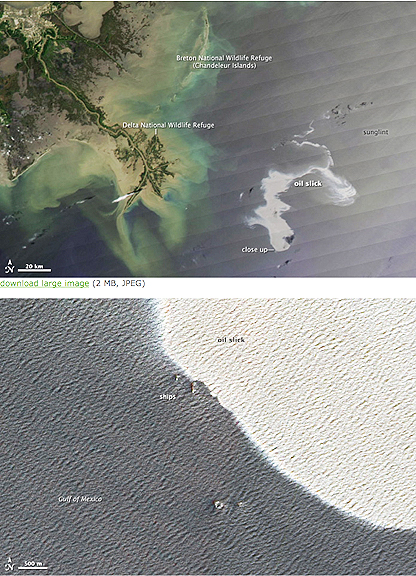
In the top image, the Mississippi Delta is at image center, and the oil slick is a silvery swirl to the right. The oil slick may be particularly obvious because it is occurring in the sunglint area, where the mirror-like reflection of the Sun off the water gives the Gulf of Mexico a washed-out look. The close-up view shows waves on the water surface as well as ships, presumably involved in the clean up and control activities.
The images, captured on April 25th by the Moderate Resolution Imaging Spectroradiometer (MODIS) on NASA’s Aqua satellite and the Advanced Land Imager on NASA’s Earth Observing-1 (EO-1) satellite, show a large oil slick in the Gulf of Mexico off the coast of Louisiana and Mississippi. An estimated 42,000 gallons of oil are leaking per day into the Gulf. NASA says its imagery of the affected region is being updated twice daily from the MODIS Rapid Response Team. Emergency workers are attempting to control the spill.
The spill comes just weeks after a Chinese coal barge grounded on the Great Barrier Reef, causing damage to about two miles of coral reef, and shortly after President Barack Obama announced plans to open up new offshore drilling sites along the northern coast of Alaska, the Atlantic coast, and the Gulf of Mexico. Pretty good timing, eh?