
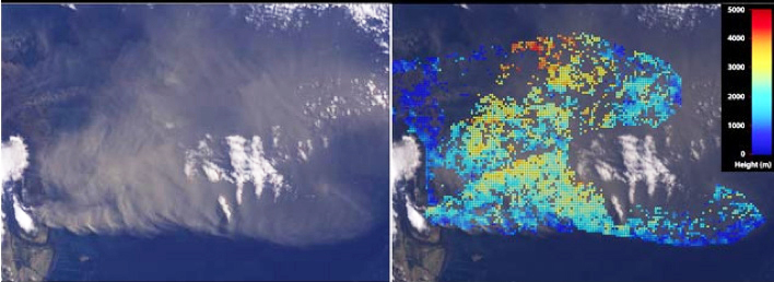
Left: a view of the ash plume from Iceland's Eyjafjallajökull volcano, taken by the nadir (vertical-viewing) camera on the Multi-angle Imaging SpectroRadiometer (MISR) instrument on NASA's Terra spacecraft. Right: a computer-analyzed map of ash plume heights, corrected to compensate for the effects of wind. Reds are highest, blue lowest. Image credit: NASA/GSFC/LaRC/JPL, MISR Team
The heights are measured in meters, with red being highest and blue lowest. The smaller streamers of the plume are just several hundred meters above the surface, whereas the main plume extends to an altitude of about 4.5 kilometers (2.8 miles). This is smaller than the 7.3 kilometer (4.5 mile) altitude measured by MISR on April 14, 2010, though conditions remain highly dynamic. The accompanying images at right show the full nadir view at top, and a stereo anaglyph at bottom. The anaglyph was generated from MISR's nadir and 46-degree forward-viewing cameras. When the anaglyph is viewed through 3-D glasses, the plume height can be estimated.