
...along the East Coast, it brought damage to NASA's Wallops Flight Facility in Wallops Island, Virgina. The Wallops Shoreline Protection Project has been managing the restoration efforts and released before and after photos of the shoreline. At 8:00 a.m. EDT, on October 29, 2012, the National Hurricane Center reported tropical-storm-force winds were occurring along the coasts of southern New Jersey, Delaware and eastern Virginia. Tropical-storm-force winds extended as far inland as the central and southern Chesapeake Bay as Hurricane Sandy closed in for landfall. Hurricane Sandy removed about 700 feet of protective berm and about 20 percent of the beach protecting Wallops Island, home to NASA Wallops' launch pads and launch support facilities. The beach, which had been recently improved under the Wallops Island Shoreline Protection Project is vital to protecting the more than $1 billion in NASA and governmental assets on Wallops Island from hazards such as hurricanes and nor'easters. In addition to beach erosion, Hurricane Sandy caused minor roof, door and siding damage and downed trees throughout the facility.
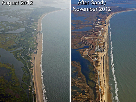
Aerial photographs of the NASA Wallops facility and coastline. On the left is from August 2012 after completion of a Shoreline Protection Project. On the right is from November 2012 after Hurricane Sandy swept by. Credit: NASA
NASA Goddard Space Flight Center's Wallops Flight Facility (WFF) was established in 1945 by the National Advisory Committee for Aeronautics as a center for aeronautics research, and is now NASA's principal facility for managing and implementing suborbital research programs. WFF is located in the northeastern portion of Accomack County, Virginia, on the Delmarva Peninsula, and is comprised of three land masses: the Main Base, Wallops Mainland and Wallops Island. Wallops Island consists of approximately 1,680 hectares (4,600 acres), is bounded by Chincoteague Inlet to the north, Assawoman Island to the south, the Atlantic Ocean to the east and estuaries to the west.