
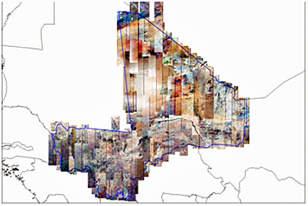
SPOT 6: national mosaic for Mali—1,241,000 km² in
less than five months.
...IGN France International (IGN FI) to update basemaps of Mali. IGM, Mali’s national survey and mapping agency, will be receiving the most recent detailed data at a resolution of 1.5 m from SPOT 6, which has covered the country’s entire 1,241,000 km² in less than five months. In October 2012, IGN FI, the subsidiary of France’s national survey and mapping agency IGN, won a bid to revise 1:200,000 scale topographic maps of Mali and support IGM’s modernisation process.
Starting in November 2012, Astrium Services kicked off a campaign—before the new satellite had even completed in-orbit checkout—to acquire SPOT 6 imagery of the whole of Mali during the dry season, thus avoiding the period of sandstorms in the desert and Sahel regions, as well as the cloud cover of the rainy season. In less than five months, north–south strips up to 600km long were acquired to obtain cloud-free coverage of Mali’s 1,241,000 km². These acquisitions are the most recent, uniform dataset of the country and provide the sharp detail required to interpret its not-very-contrasting landscapes.
In March this year, IGN FI selected Astrium Services’ SPOT 6 satellite as its main source of photo-interpretation data to revise Mali’s maps. SPOT 6’s responsiveness, image detail and rapid acquisition of the entire country are what swayed the decision for IGN FI, which will be leading this project scheduled to last four years. Maps will be produced in Mali under a technology transfer and training agreement to generate a full orthoimage of the country, cut into 138 topographic maps at a scale of 1:200,000 and distributed via a web portal. The first batch of images have already been delivered to cartographers in Bamako. With this first national mosaic contract, the SPOT 6 satellite is proving its unrivalled performance at this level of accuracy. Its agile systems and optimised response to weather forecasts enabled this vast territory to be covered in record time, while assuring a very high standard of image quality. SPOT 6 will be joined early in 2014 by its twin SPOT 7. With SPOT 6 and SPOT 7 operated as a constellation by Astrium Services, the time taken to cover large areas will be reduced by half.