
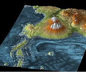
This TanDEM-X image shows Salar de Uyuni, the largest salt flats in the world covering 10,000 square kilometres, located next to the volcanic region of the Atacama Desert. The blue to dark blue areas show the lowest lying parts of the salt flats. A trained eye can see the boundaries of rock deposits in the three-dimensional model. This information about landscape features helps us draw important conclusions about the origins and development of the area. Credit: DLR.
The TanDEM-X mission was developed by the German Aerospace Center in collaboration with Astrium, and is operated from DLR Oberpfaffenhofen. The objective of the mission is to create a highly accurate three-dimensional elevation model of Earth's entire surface.
Immediately after it was launched to its 514-kilometre high orbit on 21 June 2010, the satellite was operating nominally, and sent back its first high resolution images after just three and a half days. TanDEM-X was thoroughly tested and calibrated over the following months.
This included the first close formation flight with TerraSAR-X, launched in 2007, during which the two radar satellites flew at a distance of just a few hundred metres from each other. This formation flight made it possible to take simultaneous images of Earth's surface from two different points of view - crucial to the three-dimensional mapping of the entire globe.
"The next step towards our global three-dimensional map was commissioning the control and processing chains and confirming the predicted quality of the first digital three-dimensional models," says Dr. Manfred Zink, TanDEM-X Project Manager for the ground segment at DLR. Completion of this phase means that now nothing stands in the way of full operation in early 2011.
A global network of ground stations
"Given the vast amount of data collected by the two satellites, one of our major challenges was getting the data back to Earth," says Zink. The TanDEM-X mission alone needs four ground stations.
Along with the stations for TerraSAR-X, this adds up to a global network of more than 10 ground stations. This makes possible the 'handover', in which a ground station has to switch from one satellite to the other in less than 20 seconds as they fly overhead.
After optimised data transmission, precise knowledge of how close to each other the two satellites are flying is essential. This baseline must be known to within a millimetre. Deviations from this precision can lead to altitude errors of up to a metre in the final map.
The satellites are equipped with special GPS receivers, built by the German Research Center for Geosciences, Potsdam (Geo-Forschungszentrum GFZ), which enable high-precision location determination. Combined with geographical reference data, this makes possible the necessary millimetre-accuracy baseline information. This procedure can also be verified.
Our world in three dimensions
The satellite pair will map the Earth's entire surface (150 million square kilometres) over the next three years, providing data for a unique global elevation model. The remarkable thing about this model is its accuracy (under 2 metres) and homogeneity. Global, uniform, highly accurate and in high resolution - the resulting elevation model will have a multitude of commercial and scientific applications. One example of the commercial exploitation of this accurate data is via the creation of topographical maps. The first data provided by the satellites has already been used for crisis management in response to the eruption of the Indonesian volcano Mount Merapi, by predicting the movement of lava flow. Due to this it was possible to evacuate affected areas in time.
This article can be found phenom here.