
TanDEM-X radar satellite, image courtesy of EADS Astrium
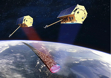
Approximately ten minutes later, the satellite separated from the launch vehicle’s upper stage. The first signals from the satellite were received by the Norwegian “Troll” ground station in Antarctica at 04:45 hours. TanDEM-X will operate in tandem with its almost identical twin, the TerraSAR-X satellite that became operational in 2007. Together, the pair of satellites will survey the entire surface of the Earth from an altitude of 514 kilometres. They will pass over each region many times, gathering data with which to construct an elevation model of the globe — covering no less than 150 million square kilometres. TerraSAR-X, Synthetic Aperture Radar Satellite, photo courtesy of EADS Astrium
The total estimated cost of the TanDEM-X mission amounts to 165 million euros. Of this sum, the DLR will contribute 125 million euros, while the European space company Astrium will provide the remaining 40 million euros from its own resources. The TanDEM-X mission is being implemented and jointly financed by the German Aerospace Centre (DLR) and Astrium GmbH under the terms of a public-private partnership (PPP) agreement and with the support of the German Federal Ministry of Economics and Technology (BMWi). Astrium subsidiary Infoterra GmbH is responsible for the commercial marketing of the TanDEM-X elevation model.