
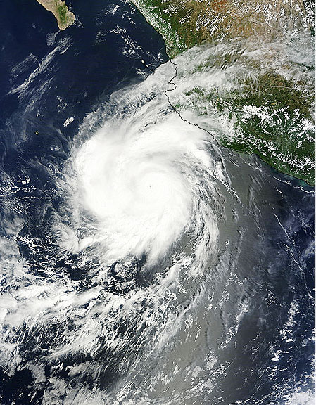
This visible image of Hurricane Hilary was captured by the MODIS instrument on Saturday, Sept. 24 at 17:40 UTC (1:40 p.m. EDT) when it was off the west coast of Mexico. Credit: NASA Goddard MODIS Rapid Response Team
Text credit: Rob Gutro, NASA's Goddard Space Flight Center, Greenbelt, Md.
At 5:00 a.m. EDT (2:00 a.m. PDT) on Sept. 26, Hilary's maximum sustained winds were near 120 mph (195 kmh). It was centered near 16.9 North and 112.2 West, about 440 miles (710 km) south-southwest of the southern tip of Baja California. It is moving away from Mexico to the west at 10 mph (17 kmh) and has a minimum central pressure of 959 millibars. Hilary is going through some changes today. It appears slightly elongated today from north to south. Cloud top temperatures in infrared satellite imagery indicate that her cloud tops are cooling, indicating they're going higher (and getting stronger). The National Hurricane Center forecast calls for Hilary to change course and take a northeastern track, coming close to Baja California by the end of the week, but as a depression. Forecasters and NASA satellites are keeping a close eye on Hilary this week.

This visible image of Typhoon Nesat was captured by the MODIS instrument on Sunday, Sept. 25 at 2:40 UTC as its western edges began to spread over the Philippines. Nesat's eye is not visible in this image. Credit: NASA Goddard MODIS Rapid Response Team
Text credit: Rob Gutro NASA/Goddard Space Flight Center, Greenbelt, Md.
Satellite imagery shows tightly-curved bands of thunderstorms wrapping into the low level center of circulation. That's an indication the storm is well-organized. The strongest convection and thunderstorms are mostly over the western semi-circle of the storm today. Microwave satellite data does reveal Nesat has an eye which helps forecasters pinpoint Nesat's center. PAGASA, the Philippines' meteorological service expects Nesat (Pedring) will make landfall Tuesday afternoon (local time/Philippines) over Casiguran, Aurora and will be in the vicinity of Baguio City. Coastal areas can expect dangerous surf and high ocean swells, heavy rainfall and gusty winds. Many watches and warnings are in effect. A Signal 3 (for the strongest winds) has been posted for many locales. The Joint Typhoon Warning Center forecasts Nesat to continue tracking due west over Luzon and make landfall with maximum sustained winds near 90 knots (103 mph/166 kmh). It is forecast to cross Luzon and move into the South China Sea in one day.