
The Landsat Data Continuity Mission (LDCM) Launch Readiness Review (LRR) gave a tentative "go” for launch. NASA’s LDCM mission is targeted for Monday, February 11 at 10:02 a.m. PST at the beginning of a 48-minute window from Space Launch Complex-3 at Vandenberg Air Force Base in California. Today’s L-3 forecast shows a 100 percent chance of favorable weather conditions for launch.
Weather Forecast
Overall probability of violating weather constraints: 0%
Primary concern(s): None
Overall probability of violating weather constraints for 24 hour delay: 0%
Primary concern(s): None

The United Launch Alliance (ULA) team is proud to be the launch provider for the Landsat Data Continuity Mission (LDCM).
The Landsat series of satellites, developed and operated by the U.S. Geological Service (USGS), has collected a continuous set of global multi-spectral land data for more than four decades. Once in orbit, the LDCM satellite will become Landsat 8, and will take over for the venerable, but aging Landsat 7 which has been in service seven years beyond its design life. Landsat 8 will scan the entire globe on an annual basis, with a complete U.S. territory data set collected every 16 days.
LDCM incorporates sensing and data capture capability improvements and will continue and expand Landsat’s vital legacy of Earth image collection. The data from Landsat is freely available and provides critical information to people who work in agriculture, geology, forestry, regional planning, education, mapping, and global change research. The ULA team is focused on attaining Perfect Product Delivery for the LDCM mission.
The LDCM mission marks the first Atlas V launch from the West Coast with our partners the National Aeronautics and Space Administration (NASA). My thanks to the entire team for its dedication in bringing
The Landsat Data Continuity Mission is NASA’s eighth satellite in the Landsat series and continues the Landsat program’s critical role in monitoring, understanding and managing the resources needed for human sustainment such as food, water and forests. As our population surpasses seven billion people, the impact of human society on the planet will increase, and Landsat monitors those impacts as well as environmental changes.
Since 1972, NASA’s Landsat fleet has provided the longest continuous record of the Earth’s surface as seen from space, providing the world with unprecedented information on land cover changes. The knowledge gained from 40 years of continuous data contributes to research on climate, carbon cycle, ecosystems, water cycle, biogeochemistry and changes to Earth’s surface, as well as our understanding of visible human effects on land surfaces. Data collected by Landsat has, over time, led to the improvement of human and biodiversity health, energy and water management, urban planning, disaster recovery and agriculture monitoring, all resulting in incalculable benefits to the U.S. and world economy. Landsat data have been used to monitor water quality, glacier recession, sea ice movement, invasive species encroachment, coral reef health, land use change, deforestation rates and population to assess damage from natural disasters such as fires, floods, and tsunamis, and subsequently, plan disaster relief and flood control programs.
Weighing in at approximately 6,100-lb, fully fueled, the satellite bus is built by Orbital Sciences Corporation, and supports the Operational Land Imager (OLI) and Terrestrial Infrared System (TIRS) as the primary instruments. With each pass, OLI will collect Earth views in the visible, near infrared and short wave infrared portions of the light spectrum with up to 49 ft resolution along a 115-mile wide swath. TIRS will measure land surface temperature in two thermal infrared bands with a new technology that applies quantum physics to detect heat. LDCM will be positioned in a nearly-polar, sun-synchronous orbit which allows a view of the entire Earth once every 16 days and will measure the Earth’s surfaces in four distinct frequency bands.
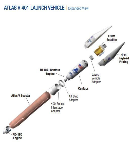
The Atlas V 401 consists of a single Atlas V booster stage, the Centaur upper stage, and a 4-m diameter payload fairing (PLF). The Atlas V booster is 12.5 ft in diameter and 106.5 ft in length. The booster’s tanks are structurally rigid and constructed of isogrid aluminum barrels, spun-formed aluminum domes, and intertank skirts. Atlas booster propulsion is provided by the RD-180 engine system (a single engine with two thrust chambers). The RD-180 burns RP-1 (Rocket Propellant-1 or highly purified kerosene) and liquid oxygen, and delivers 860,200 lb of thrust at sea level. The Atlas V booster is controlled by the Centaur avionics system, which provides guidance, flight control, and vehicle sequencing functions during the booster and Centaur phases of flight.
The Centaur upper stage is 10 ft in diameter and 41.5 ft in length. Its propellant tanks are constructed of pressure-stabilized, corrosion resistant stainless steel. Centaur is a liquid hydro- gen/liquid oxygen- (cryogenic-) fueled vehicle. It uses a single RL10A-4-2 engine producing 22,300 lb of thrust. The cryogenic tanks are insulated with a combination of helium-purged insulation blankets, radiation shields, and spray-on foam insulation (SOFI). The Centaur forward adapter (CFA) provides the structural mountings for the fault-tolerant avionics system and the structural and electrical interfaces with the spacecraft.
The LDCM mission is encapsulated in the 4-m (14-ft) diameter extended payload fairing (EPF). The EPF is a bisector (two-piece shell) fairing consisting of aluminum skin/stringer construction with vertical split-line longerons. The vehicle’s height with the PLF is approximately 192 ft.