
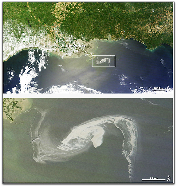
On April 29, the MODIS image on the Terra satellite captured a wide-view natural-color image of the oil slick (outlined in white) just off the Louisiana coast. The oil slick appears as dull gray interlocking comma shapes, one opaque and the other nearly transparent. Sunglint — the mirror-like reflection of the sun off the water — enhances the oil slick’s visibility. The northwestern tip of the oil slick almost touches the Mississippi Delta. Credit: NASA/Earth Observatory/Jesse Allen, using data provided courtesy of the University of Wisconsin’s Space Science and Engineering Center MODIS Direct Broadcast system.
A semisubmersible drilling platform called the Deepwater Horizon located about 50 miles southeast of the Mississippi Delta experienced a fire and explosion at approximately 11:00 p.m. CDT on April 20. Subsequently, oil began spilling out into the Gulf of Mexico and efforts to contain the spill continue today. NASA's Terra and Aqua satellite imagery has captured the spill in between cloudy days. NOAA used data from the Moderate Imaging Spectroradiometer or MODIS instrument from the Terra satellite on April 26, 27, and 29 to capture the extent of the oil spill, which measured 600-square-miles. The MODIS instrument flies aboard both the Terra and Aqua satellites.
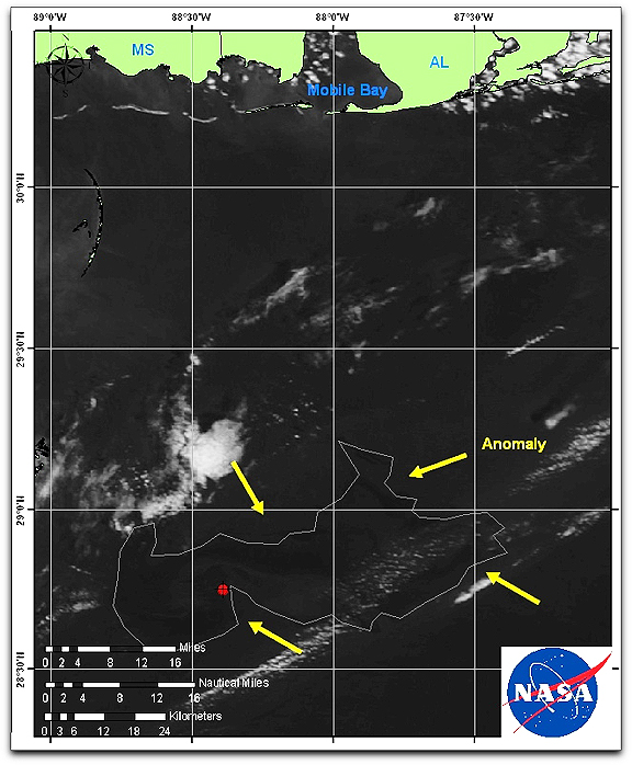
This satellite image from NASA's Terra satellite on April 27 at 12:05 CDT shows the outline and extent of the oil slick from the Deepwater Horizon drilling platform. The red dot represents the platform. The coasts of Mississippi and Alabama appear at the top of the image. Credit: NOAA/NASA
On April 30, NOAA declared the Deepwater Horizon incident "a Spill of National Significance (SONS)." A SONS is defined as, "a spill that, due to its severity, size, location, actual or potential impact on the public health and welfare or the environment, or the necessary response effort, is so complex that it requires extraordinary coordination of federal, state, local, and responsible party resources to contain and clean up the discharge" and allows greater federal involvement. NOAA's estimated release rate of oil spilling into the Gulf is estimated at 5,000 barrels (210,000 gallons) per day based on surface observations and reports of a newly discovered leak in the damaged piping on the sea floor. NOAA reported on April 29 that dispersants are still being aggressively applied to the oil spill and over 100,000 gallons have been applied. NOAA's test burn late yesterday was successful and approximately 100 barrels of oil were burned in about 45 minutes. NOAA is flying planes over the area and using NASA satellite imagery from the Terra and Aqua satellites to monitor the spill.