
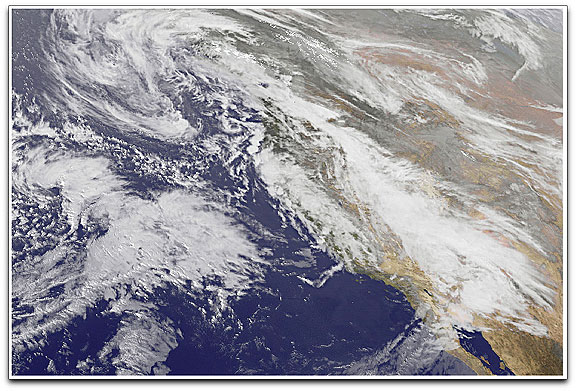
The Geostationary Operational Environmental Satellite (GOES) — built and launched by NASA, operated by the National Oceanic and Atmospheric Administration — captured a series of images of the storm activity between January 19 and 21, 2010. The image above was acquired at 4:46 p.m. Pacific Time on January 19 (00:46 UTC on January 20). The satellite’s vantage point is over the Pacific Ocean, west of the California coast, and the image captures three cloud banks on their journey eastward. One is over the ocean, another occurs along the coast, and another has traveled inland, extending as far south as mainland Mexico. Animations show successive waves of storm clouds breaking over California between January 19 and 21, 2010.
On January 19, the same day GOES acquired this image, the National Weather Service reported rain totals of 1.10 inches (2.79 centimeters) at Fullerton Airport, 1.38 inches (3.51 centimeters) at Modjeska Canyon, and 1.15 inches (2.92 centimeters) at Palomar Mountain. Heavy rains continued over the next two days. Thunderstorms knocked out power in Northern and Southern California, and flooded streets in the Los Angeles area. Authorities ordered hundreds of residents of the Los Angeles foothills to evacuate ahead of potential mudslides from areas devastated by the Station Fire, which had scorched the area months earlier. As of January 21, forecasters were warning Californians to brace for yet another storm.