
Photos by Pat Corkery, United Launch Alliance.
The launch of the AEHF-1 mission is set for Saturday with a launch window of 7:07-9:06 a.m. EDT. The AEHF constellation of satellites will provide 10 times greater capacity and channel data rates six times higher than that of the existing Milstar II communications satellites.
On Saturday, August 14, the live broadcast coverage of the Atlas V AEHF-1 launch will begins at 6:47 a.m. EDT and will conclude 55 minutes after launch. Listed below are the satellite coordinates for the launch:
14 AUGUST (ALL TIMES ARE EASTERN DAYLIGHT TIME)
- Test signals begin: 6:30 A.M.
- Broadcast start: 6:47 A.M.
- SATELLITE – GALAXY 3
- TRANSPONDER – G3C-8C
- BAND – C-BAND ANALOG
- ORBITAL POSITION – 95 DEGREES W
- CARRIER – INTELSAT
- BANDWIDTH – 36 MHz
- UPLINK FREQ – 6085 MHz (HORIZONTAL)
- DOWNLINK FREQ – 3860 MHz (VERTICAL)
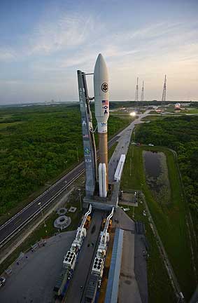
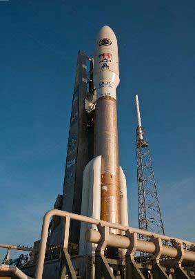
The Air Force’s first Advanced EHF satellite, encapsulated in its 5-meter payload fairing, is mated to an Atlas V booster.
WEATHER FORECAST:
Overall probability of violating weather constraints: 20% Primary concern(s): Cumulus Clouds
Overall probability of violating weather constraints for 48 hour delay: 40%; Primary concern(s): Cumulus Clouds
Summary:
The high pressure axis is South of Central Florida with a broad area of low pressure off the Eastern seaboard and trailing surface trough in the Gulf coast states. In this regime pattern with Westerly winds, thunderstorms developing by noon to early afternoon along the seabreeze boundary are expected with the boundary remaining near I-95 through the afternoon.
Steering winds will transport showers and thunderstorms back toward the East coast. For MLP roll today, fair weather conditions are expected in the morning with a loose pressure gradient and light West-southwest winds during the roll gusting to 12 kts (230 feet). Isolated showers and thunderstorms are expected to develop along the seabreeze boundary by noon to early afternoon. Steering level winds will steer developing thunderstorms back toward the East coast.
The Air Force’s first Advanced EHF satellite, rolls out to its launch pad at Space Launch Complex-41 at Cape Canaveral Air Force Station, Fla., in preparation for launch.