
 [SatNews] As the tornados touched down in Oklahoma a few weeks ago, first responders jumped into action. In support of these brave and motivated people and organizations, DigitalGlobe tasked its satellite constellation to capture imagery of the area as part of its FirstLook service, collecting high resolution panchromatic WorldView-1 satellite imagery as well as color GeoEye-1 imagery.
Upon collection, DigitalGlobe launched it’s recently acquired Tomnod Crowdsourcing System (TCS) to help extract the information from the image. The Tomnod approach is most powerful in situations where rapid insight is required in order to enable fast decision making. For Moore, Oklahoma, deployed the Tomnod system on the imagery was immediately deployed to help convert the plethora of pixels to information.
An email rallied our Tomnod crowd to the new campaign. In addition we sent out the call on Facebook and Twitter and to dedicated groups, such as CrisisMappers. Users that came to the site were given a short tutorial and then asked to view imagery and identify destroyed buildings, tarped roofs, and fallen trees. On the backend, the CrowdRank score of each location and each member of our crowd was constantly analyzed. CrowdRank is DigitalGlobe's statistical reliability algorithm that combines the crowd’s inputs to zero-in on the most accurate results. Within 60 minutes, more than 15,000 points of interest had been collected and the crowdsourced damage assessment map was published. Within one hour, based on the crowd inputs, CrowdRank identified the damage areas in Moore
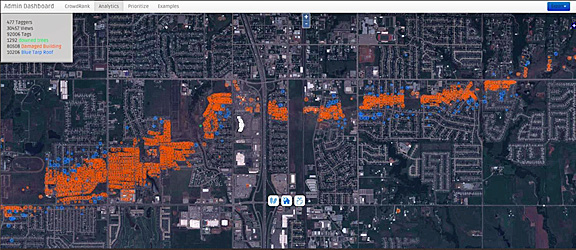
The damage map above immediately highlights the trail of total destruction left by the tornado [orange]. Just off of the main path of the tornado, the tarped roofs that had been identified [blue] where buildings were partially damaged by high winds or flying debris can be seen.

The crowdsourcing process is meant to reduce the time between data collection and decisions. Therefore, it is critical to distribute these results quickly and efficiently. The damage assessment map is immediately available in a variety of formats, such as SHP, WFS, and KMZ. In the produced KMZ file, included is an image chip of the location that had been damaged accessible in a lightweight package.
Would you like to become involved Please sign-up for DigitalGlobe's latest project—help to find the burned buildings destroyed in Colorado’s Black Forest Fire.
