
...gravity map of Earth, but its orbit is now being lowered in order to obtain even better results.
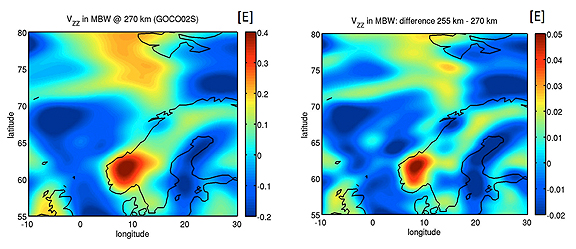
The image on the left shows GOCE’s gravity measurements over northern Europe, acquired from its previous altitude. The image on the right depicts the expected measurements over the same area after the satellite has been lowered by 15 km. An increased signal and improved spatial resolution is evident.
Credits: ESA / GOCE+ Theme 2
The Gravity field and steady-state Ocean Circulation Explorer (GOCE) has been orbiting Earth since March 2009, reaching its ambitious objective to map our planet’s gravity with unrivalled precision. Although the planned mission has been completed, the fuel consumption was much lower than anticipated because of the low solar activity over the last two years. This has enabled ESA to extend GOCE’s life, improving the quality of the gravity model.
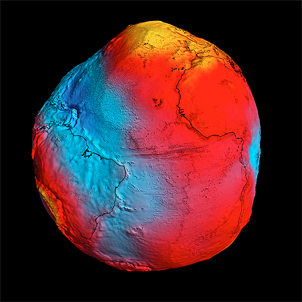
ESA's GOCE mission has delivered the most accurate model of the 'geoid' ever produced, which will be used to further our understanding of how Earth works.
The colors in the image represent deviations in height (–100 m to +100 m) from an ideal geoid. The blue colours represent low values and the reds/yellows represent high values.
A precise model of Earth's geoid is crucial for deriving accurate measurements of ocean circulation, sea-level change and terrestrial ice dynamics. The geoid is also used as a reference surface from which to map the topographical features on the planet. In addition, a better understanding of variations in the gravity field will lead to a deeper understanding of Earth's interior, such as the physics and dynamics associated with volcanic activity and earthquakes.
Credits: ESA/HPF/DLR
Lowering the orbit increases the accuracy and resolution of GOCE’s measurements, improving the view of smaller ocean dynamics such as eddy currents. The control team began the manoevers in August, lowering GOCE by about 300m per day. After coming down by 8.6km, the satellite’s performance and new environment were assessed. Now, GOCE is again being lowered while continuing its gravity mapping. Finally, it is expected to reach 235km in February.
As the orbit drops, atmospheric drag increasingly pulls the satellite towards Earth. But GOCE was designed to fly low, the tiny thrust of its ion engine continuously compensating for any drag. The expected increase in data quality is so high that scientists are calling it GOCE’s ‘second mission.’
The first ‘geoid’ based on GOCE’s gravity measurements was unveiled in June 2010. It is the surface of an ideal global ocean in the absence of tides and currents, shaped only by gravity. A geoid is a crucial reference for conducting precise measurements of ocean circulation, sea-level change and ice dynamics. The mission has also been providing new insight into air density and wind in space, and its information was recently used to produce the first global high-resolution map of the boundary between Earth’s crust and mantle.