
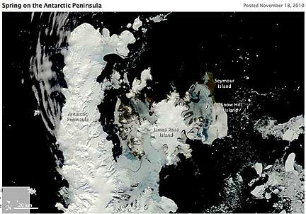
The peninsula and the surrounding islands were rapidly loosing the shield of sea ice that surrounds them in the winter. Winds had been blowing from the west, pushing the sea ice east, towards the lower right corner of the image. The east-blowing winds (westerly winds) channeled down the mountains, bringing warmer air to the east side of the peninsula. The remaining sea ice around the James Ross, Seymour, and Snow Hill Islands melted in response. The water-saturated ice is pale blue.
Scientists are very interested in the Antarctic Peninsula because it has warmed significantly since weather stations began collecting data there. In the past decade, the Larson B and Wilkins Ice Shelves collapsed at least partly because of warming temperatures. The ice shelves had acted as a stop slowing the flow of glaciers from the mountainous peninsula into the ocean. With the shelves gone, the glaciers accelerated their flow, rapidly shedding ice into the ocean.
To better understand how the glaciers responded in the years since the ice shelves collapsed, NASA scientists are flying over the peninsula in a plane equipped with instruments to measure how the ice is changing. So far, many glaciers, including the Crane Glacier, have not slowed their flow. The flights are part of NASA’s IceBridge Mission.
If weather permits, NASA IceBridge scientists will be available for a live chat from the mission’s base in Punta Arenas, Chile on Thursday, November 18, 2010, 1-2 EST.