MetaVR's Virtual Afghan Terrain Derived From SatImagery For NATO Warfighter Training
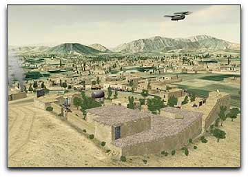
To meet the needs of training NATO soldiers for warfare in Afghanistan, MetaVR has built 3D geospecific terrain covering 9,600 square kilometers, featuring a high-resolution virtual village with more than 500 buildings in the Afghan province of Kabul.
This virtual terrain is available in
MetaVR's round-earth and flat-earth formats for use with
Virtual Reality Scene Generator™ (
VRSG™) for simulation and training, with particular emphasis on identifying and defeating IEDs using resources from combined military branches and nations. The terrain is also delivered with correlated SAF databases in CTDB and OTF formats. Unlike the simplified, flattened terrain used to simulate urban environments in most image generators and video games, MetaVR’s Afghan village is set within mountains, complex terrain of varying elevation, and cave complexes enabling realistic training scenarios for operations in mountainous villages. This virtual terrain, built with
MetaVR Terrain Tools for
ESRI ArcGIS, includes 1,120 square kilometers of 60-cm
Digital Globe commercial satellite source imagery and 90 meter elevation posts and features a highly detailed 2 x 2 km inset terrain patch of a geospecific Afghan village. The effective terrain elevation resolution is much higher in the village areas as the construction of inferred cultural features from the geospecific imagery such as roads, buildings, courtyards, tree line, and crops further define the elevation relief. This terrain is built entirely from commercial, non-export controlled source data. Using MetaVR’s new terrain work flow process, additional terrain areas can be readily constructed.
The modeled village is based on the village of
Khairabad in the southern part of the
Kabul province. Khairabad, situated at an altitude of 1,843 meters, is located approximately 10-15 kilometers south of the Kabul city center, next to Qalai Naeem in the Char Asiab district. This virtual village and its surrounding mountainous terrain give users the ability to conduct ground combat simulations, such as sniper and forward air controller (JTAC) exercises, with a high degree of realism. Real-time recordings of a JTAC exercise scenario and other warfighter training scenarios based on the Afghanistan virtual terrain, can be viewed on MetaVR’s web site. MetaVR’s Afghanistan 3D terrain, built in collaboration with
Simthetiq and
VR Group, is available free of charge in MetaVR’s terrain formats and SAF formats to all U.S. Government and NATO agency and contractor customers (for official use only) on active software maintenance (VRSG version 5.5 required).
Topical Tags :
Regional Tags :
