

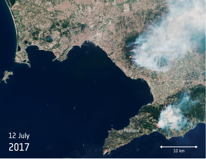
As if high summer temperatures aren't enough to make Italians feel uncomfortable, now there are wildfires that add to their aggravation. There is such a large plume of smoke around Mount Vesuvius it led some people to believe the volcano was erupting again.
Vesuvius on Fire — Released 13/07/2017 2:30 pm Copyright contains modified Copernicus Sentinel data (2017), processed by ESA, CC BY-SA 3.0 IGO
With Italy suffering high temperatures and drought, wildfires have broken out including blazes that are ravaging the slopes of Mount Vesuvius near Naples. Using images taken by the Copernicus Sentinel-2B satellite on 12 July 2017, the animation combines different sensor bands to highlight the numerous separate fires around this iconic volcano and the smoke billowing over the surrounding area.
This huge plume of smoke led some to believe that Vesuvius was erupting again. The last time it erupted was back in 1944, but is most famous for the 79 AD eruption that destroyed Pompeii.
The smoke from these fires poses the biggest threat and has forced several evacuations this week. The wooded slopes of Vesuvius form part of the Vesuvio National Park, which was set up in 1995 to protect the volcano and surroundings. Much of the woodland is now destroyed.
Vesuvius is the only active volcano on mainland Europe. The animation also shows another fire and smoke near Positano on the Amalfi coast.
The Sentinel-2 mission is based on a constellation of two identical satellites: Sentinel-2A and Sentinel-2B. Each carries a high-resolution multispectral camera working in 13 wavelength bands for a new perspective on land and vegetation. The combination of high-resolution, novel spectral capabilities, a field of vision covering 290 km and frequent revisit times is providing unprecedented views of Earth. Information from this mission is helping to improve agricultural practices, monitor the world’s forests, detect pollution in lakes and coastal waters, and contribute to disaster mapping.