
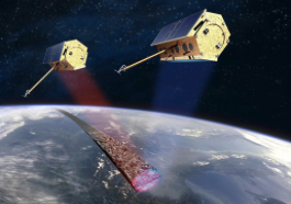
TanDEM-X (‘TerraSAR-X add-on for Digital Elevation Measurement’) is an Earth observation satellite, which, together with the almost identical TerraSAR-X radar satellite, forms a high-precision
radar interferometer system.
[Satnews] The 3D nature of the data provides an ideal visualization tool indispensable for surveillance, reconnaissance and mission planning...
Airbus Defence and Space and the German Ministry of Defense have signed a contract for the utilization of TanDEM-X mission data, to update the Digital Elevation Model (DEM) of the Bundeswehr. The agreement includes both licenses for the utilization of the global elevation data set covering the 150 Mio km² of the Earth’s landmass, and support services for data-management and data-editing, helping to access, edit, store and disseminate the impressive volume of data. Additional support and training will also be provided under the agreement, so users can reap the full benefits of this unique and homogenous global dataset.

The TanDEM-X mission will create a global Digital Elevation Model (DEM) with unprecedented accuracy.
© Airbus Defence and Space / Thomas Ernsting / 2010
The TanDEM-X Digital Elevation Model was acquired by the TanDEM-X Mission realized as a Public Private Partnership (PPP) between Airbus Defence and Space and the German Aerospace Center (DLR). It provides the first global, consistent, single-source and high-precision Digital Elevation Model, establishing a new standard for global elevation. Airbus Defence and Space holds the exclusive commercial rights for these data which are marketed under the name of WorldDEM and has developed a dedicated software tool for the adaptation of the elevation data to the needs of military and commercial users worldwide.
“We are proud of the trust shown by the German Ministry of Defense, which now becomes the first user of the global information provided through WorldDEM” says Evert Dudok, Executive Vice President of Communications, Intelligence and Security (CIS) Business Line at Airbus Defence and Space.
The 3D nature of the data provides an ideal visualization tool indispensable for surveillance, reconnaissance and mission planning. The TanDEM-X Digital Elevation Model facilitates the interpretation of landscapes with exceptional detail, which is essential for military engineering projects and operational planning including mapping of obstacles, line of sight estimation and flight path/possible landing site planning.