

[SatNews] During the summer of 2015, wildfires raged across the western United States and Alaska—many of those fires burned in the U.S. Northwest, visible in this image from late August, 2015.
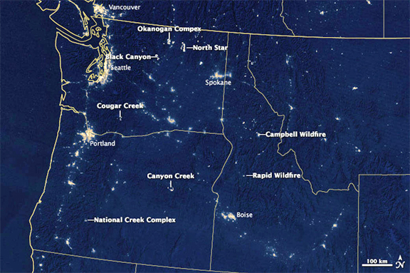
This image was acquired in the early morning local time on August 19 with the Visible Infrared Imaging Radiometer Suite (VIIRS) sensor on the Suomi NPP satellite. The image was made possible by the instrument’s “day-night band,” which uses filtering techniques to observe dim signals including those from wildfires. Labels point to the large, actively burning fires in the region.
According to the Northwest Interagency Coordination Center, the Okanogan Complex Fire in Washington was among the larger active fires; as of August 20, the fire had burned 91,314 acres (370 square kilometers, or 143 square miles). In Oregon, the Canyon Creek Complex Fire had burned 48,201 acres (195 square kilometers, or 75 square miles), destroyed 26 residences and threatened another 500. Both fires were less than 40 percent contained. Meanwhile, firefighters have made progress on the large, damaging Cornet-Windy Ridge Fire in Oregon, which as of August 20 was 70 percent contained; smoke from this fire is more visible in earlier images.
NASA Earth Observatory images by Jesse Allen and Joshua Stevens, using VIIRS day-night band data from the Suomi National Polar-orbiting Partnership. Suomi NPP is the result of a partnership between NASA, the National Oceanic and Atmospheric Administration, and the Department of Defense.