
[SatNews] "The findings suggest that satellite radar is the perfect tool to identify volcanic unrest"...
London: Satellite imagery can be used to predict which volcanoes are most likely to erupt, scientists have found.
Volcano deformation and, in particular, uplift are often considered to be caused by magma moving or pressurizing underground, researchers said.
Magma rising towards the surface could be a sign of an imminent eruption, they said.
On the other hand, many other factors influence volcano deformation and, even if magma is rising, it may stop short, rather than erupting.
Dr Juliet Biggs and colleagues from the University of Bristol, with collaborators from Cornell, Oxford and Southern Methodist University, looked at the archive of satellite data covering over 500 volcanoes worldwide, many of which have been systematically observed for over 18 years.
Satellite radar (InSAR) can provide high-resolution maps of deformation, allowing the detection of unrest at many volcanoes that might otherwise go unrecognized, researchers said.
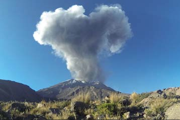
Handout picture released by the Peruvian Geological Institute INGEMMET, showing a smoke stack raising from the Ubinas volcano on September 5, 2013
Such satellite data is often the only source of information for remote or inaccessible volcanoes.
The researchers applied statistical methods more traditionally used for medical diagnostic testing and found that many deforming volcanoes also erupted (46 per cent).
Together with the very high proportion of non-deforming volcanoes that did not erupt (94 per cent), these jointly represent a strong indicator of a volcano's long-term eruptive potential.
"The findings suggest that satellite radar is the perfect tool to identify volcanic unrest on a regional or global scale and target ground-based monitoring," Biggs said.
"Improving how we anticipate activity using new technology such as this is an important first step in doing better at forecasting and preparing for volcanic eruptions," said STREVA Principal Investigator, Dr Jenni Barclay.
"Global studies of volcano deformation using satellite data will increasingly play a part in assessing eruption potential at more and more volcanoes, especially in regions with short historical records or limited conventional monitoring," co-author Professor Willy Aspinall added.
Many factors and processes, some observable, but others not, influence deformation to a greater or lesser extent.
These include the type of rock that forms the volcano, its tectonic characteristics and the supply rate and storage depth of magma beneath it.
Thus, deformation can have different implications for different types of volcanoes.
For volcanoes with short eruption cycles, the satellite record typically spans episodes that include both deformation and eruption, resulting in a high correlation between the two.
For volcanoes with long eruption cycles, satellite record tends to capture either deformation or eruption but rarely both.
The study was published in the journal Nature Communications.