

[SatNews] On July 2nd, Microsatellite Rising-2 (MR-2) succeeded in capturing high precision images of the Earth’s surface using a High Precision Telescope (HPT)—the satellite captured color images at a spatial resolution of 5m, the highest in the world for any 50kg-class satellite.
Rising-2 is a microsatellite developed by Tohoku University and Hokkaido University and was launched from the Tanegashima Space Center, Japan, on May 24, 2014, and has been conducting various test operations. Dayside cloud imagery and night views of city lights and air glow have been acquired so far using a Wide Field-of-view CCD camera (WFC), and high resolution imaging experiments using HPT have recently started. On July 2, Rising-2 succeeded in shooting detailed landscape in sunny spells during the rainy season as shown in these images. The high resolution can have a significant impact on environmental monitoring, mapping
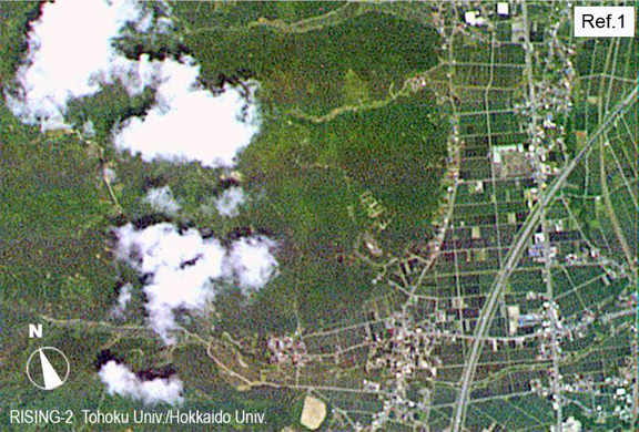
Observation Date and Time: July 2, 2014 12:09:22 (Japan Time) for Minami-Uonuma City, Niigata, Japan (about 3.2km x 2.2km)
Image copyright: Image data acquired by Rising-2 HPT.
Since 2009, the 43kg microsatellite, Rising-2, was in development based on a satellite bus system by Tohoku University, with observation equipments by Hokkaido University. MR-2 was launched on May 24, 2014, by a JAXA H-IIA Rocket. The High Precision Telescope (HPT) is one of the observation equipments onboard Rising-2. The HPT was designed as a compact (length: 38cm, aperture diameter: 10cm, weight: about 3kg,) yet highly capable imaging system to take the world’s first photographic images in 400 spectral bands, with 5m GSD (ground sample distance). The satellite uses advanced technologies, such as a liquid crystal tunable filter (LCTF), which was developed in cooperation with the Sendai National College of Technology, and a mirror using special ceramics. Rising-2 has already succeeded in capturing dayside cloud imagery and night views using a fish-lens CCD camera (WFC) since its launch, and has been attempting to take high resolution images with the HPT.
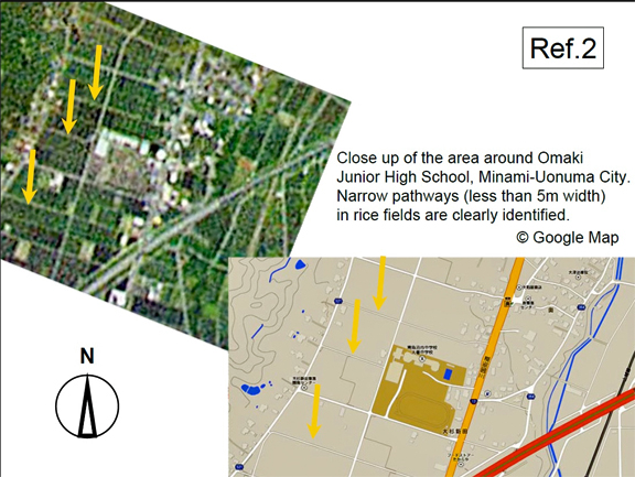
Close up of the area around Omaki Junior High School, Minami-Uonuma City. Narrow pathways (less than 5m width) in rice fields are clearly identified.
Image copyright : Image data acquired by Rising-2 HPT.
The Japanese archipelago was viewed during clear weather in the rainy season on July 2, 2014, and high resolution color images of the Earth’s surface (RGB tricolor image) were successfully acquired using the HPT. The observation area is about 3.2 x 2.2km square of Minami-Uonuma City, Niigata, Japan. The initial goal was to achieve spatial resolution of 5m at the surface, and this has been attained. This makes Rising-2 the current record holder for high resolution images from a 50kg microsatellite. These results were achieved by using the sensor technology of the HPT in combination with the advanced control of the satellite bus system. This is a significant step for 50kg class micro-satellites, showing how they can be used for practical purposes.
With an aim to conduct highly practical observations, operations to establish more accurate control of the satellite attitude are scheduled for completion. Rising-2 will also make a challenge to obtain multispectral images with the world’s first space liquid crystal tunable filter (LCTF) that allows wavelength-selection.
Tohoku University's infosite: http://www.tohoku.ac.jp/